
Menifee Valley Map Boundaries
Below is a map showing what the proposed City of Menifee Valley might look like. There's basically three proposals... Study Area 1 (in o...
http://www.menifee247.com/2007/10/menifee-valley-map-boundaries.htm
Below is a map showing what the proposed City of Menifee Valley might look like.
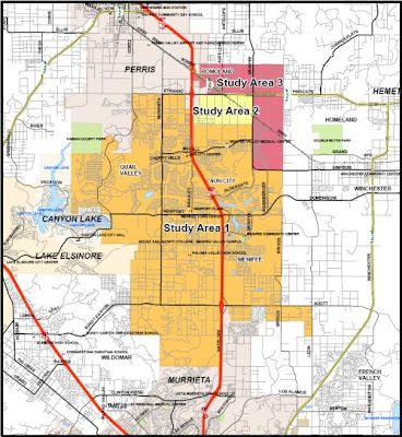
There's basically three proposals...
From what I've read, the most financially feasible is the 3rd proposal, and will most likely be what the new city will look like, assuming it passes public vote. This includes the Heritage Lakes development, the Heritage High School, Richardson's RV, the SoCal Edison Power Station, and parts of Romoland including Romola Farms.
Residents living in that part of Romoland will be included in the general vote for cityhood. There is a small effort in that part of Romoland to resist Menifee cityhood, and instead create a new future city called "Harvest Valley", but I don't think there's enough opponents there to make a significant impact on the outcome.

There's basically three proposals...
- Study Area 1 (in orange) are the original proposed boundaries
- Include both Study Area 1 and Study Area 2 (in yellow)
- Include both Study Area 1, 2, and 3 (in magenta)
From what I've read, the most financially feasible is the 3rd proposal, and will most likely be what the new city will look like, assuming it passes public vote. This includes the Heritage Lakes development, the Heritage High School, Richardson's RV, the SoCal Edison Power Station, and parts of Romoland including Romola Farms.
Residents living in that part of Romoland will be included in the general vote for cityhood. There is a small effort in that part of Romoland to resist Menifee cityhood, and instead create a new future city called "Harvest Valley", but I don't think there's enough opponents there to make a significant impact on the outcome.


There may be some opposition in Romoland to becoming part of Menifee Valley, but their next choice is to become part of Perris. I think that with the state laws the way they are it will become increasingly difficult for new cities to be formed and developed areas will continue to be annexed by neighboring cities. It was stated previously on this blog if cityhood does not pass then expect the Menifee Valley to be split up between the cities of Canyon Lake, Murrieta, and Perris. Those who would become part of Canyon Lake and Murrieta would probably do OK, but the parts that become part of Perris would most likely feel the drag of the rest of Perris' economy, and this would probably include the Sun City core neighborhoods.
ReplyDeleteI hope this issue makes it to the ballot because I think it's the last chance that we ever have of becoming a city. Either the state laws will go back to the way they were a couple years ago making it financially impossible or the area will get split up into surrounding cities. If it does make it to the ballot I will definitely vote "Yes".
Perris and Murrieta are very active in annexing more land. Canyon Lake wants to annex more land because they're land locked, and they've used up all available land.
ReplyDeleteThe entire Menifee Valley is destined to become a major business and industrial center simply because the I-215, Hwy 74, and Domenigoni Pkwy are going to become major thoroughfares by mid-century. There may not be a whole lot here now, but look at 50 years from now, and Menifee will be at the center of Riverside County's economy.
I live in the Menifee Lakes area. I would rather be annexed into Murrieta than be part of a city that includes Quail Valley, Sun City and Romoland.
ReplyDeleteMenifee Lakes is so nice with its Cow Poop Smell...
ReplyDeleteIt's not cow poop that you smell. It's the HOA!
ReplyDeleteI bought my house in Menifee & moved here 3-29-06. All paperwork from the county says Menifee & my mailing address is Menifee. This boundary map shows that my KB home subdivision is excluded from Menifee. It is located between Menifee Rd & Lindenberger Rd with Scott Rd the northern boundary. Other property east & west of us on Scott is included in Menifee. The Murrieta line is just south of our subdivision. Does anyone know WHY we are excluded?? I don't want to become part of Murrieta, or be a county island between Menifee & Murrieta. Thanks in advance for your help.
ReplyDeleteI too live in the Menifee Lakes area. Similarly I would rather be annexed into Murrieta (or just stay an unincorporated part of Riverside Cty) than be part of a city that includes Quail Valley, Sun City and Romoland.
ReplyDeleteKathy Jo, I'm not an expert on the boundaries, but from what I understand the original boundaries was supposed to end at Scott Rd.
ReplyDeleteThere was a time when Murrieta tried to annex your land (before the Berkshire community was built), which included the J-Bar Ranch. People in J-Bar resisted Murrieta's annexation bid. because they didn't want pay into Murrieta's internal political scandals. As a result, Murrieta only was able to get the land where the shopping center is (Scott & Antelope).
The people at J-Bar ranch was able to get their neighborhood included within the boundaries of Menifee Valley, but only their neighborhood. The reason why your parcel of land was excluded was because no one was living on it at the time.
You need to contact the Menifee Valley Incorporation Committee, and ask them to include you. Unfortunately, their website is no longer online. E-mail me on Menifee 24/7, and I'll give you the phone number to their Chairman.
"Menifee Valley" is ugly name. I prefer to keep "Menifee" is pretty name.
ReplyDeleteI understand Menifee is a family name dating back to original settlers of the area (at least i think i read that somewhere) but I avoid telling people I'm from "Menifee" because people make fun of the name. Adding "valley" to the title doesn't help at all.
ReplyDeleteI vote let Murrieta annex Menifee - political scandals and all. Ever heard of the MLMA? Scandals are everywhere.
I like the name Menifee Valley, it is different and distinctive...no one I have ever told has made "fun" of it..(how mature is that?)
ReplyDeleteDrive up to one of the high hills and look at our beautiful valley on a clear day, rolling hills, and snowy mountains,and brown eyed Susans growing wild on the roadways.
The residents of Menifee have the chance of doing something very special with this valley.
I lived here since 1976 we called it south of Sun city then. Frankly you'll can go back from wince you came...
ReplyDelete